
Bing Maps Snap to Road API
Looking for a tool that takes the data from your asset’s GPS traces and plots the path on a map? When analyzing your fleet’s activities, sometimes sifting through the data can be time consuming and not very effective. With the Bing Maps Snap to Road API, monitoring your assets’ activities, including the route and speed, can help your organization better manage resources, which in turn can improve driver safety, performance, and customer satisfaction.
Improved Performance and Customer Satisfaction
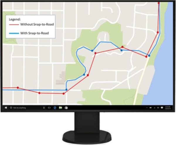
Analyzing the activities of your organization’s assets to identify opportunities for improvement is an important part of fleet and logistics management. How can the Bing Maps Snap to Road API help? An asset enabled with a GPS device leaves GPS traces, otherwise known as historical bread crumbing, throughout the route. The Bing Maps Snap to Road API service takes the list of longitude and latitude points (as shown in red in Figure 1) and returns a list of objects containing the longitude, latitude, speed limit, and street names which forms a route snapped to the most logical roads on the map. Additionally, users can request that the points be interpolated, resulting in a path that smoothly follows the geometry of the road for advanced data visualization. Use the information to understand if the driver is adhering to the posted speed limits, monitor if they go off route, determine how much time the asset has been travelling, look at overlapping routes to optimize deliveries, and more.
Data Analytics and Visualization
Often times, the GPS traces from a moving asset are not accurate when looking at historical data for each asset’s route, as the device can intermittently lose its signal or incorrectly place the GPS points off the road. With the Bing Maps Snap to Road API, you can track each asset’s route by snapping the points to the nearest roads for display purposes, as well as view the data for each point.
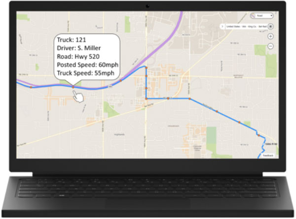
For example, a utility company can use the Bing Maps Snap to Road API to track the route a technician took to a customer’s location. In this use case, the company has set the device to collect GPS data every minute along the route. The utility company then passes the GPS points collected into the Snap to Road API to snap the GPS points so that they follow the geometry of the road and get the road names and the posted speed limits for the points along the technician’s route. In this specific example, shown in Figure 2, the utility company then added the route’s points from the Snap to Road API output onto a map using the Bing Maps Web Control. They also used the Bing Maps Web Control infobox feature to display the driver’s name, truck number, posted speed limits, road names and the truck’s actual speed so that they can monitor the truck driver’s behavior, review route efficiency, and look for ways to improve CRM and ROI.
Features and Capabilities
- Takes a list of the latitudes and longitudes collected and returns a list of objects containing latitude and longitude points, street names, and the posted speed limits for cars or trucks.
- Can request interpolated points, resulting in a path that follows the geometry of the road.
- API inputs:
- An array of coordinates (as if latitude/longitude from a GPS trace)
- Interpolate: request to interpolate between the snapped points
- Request to return Speed Limit = True/False
- API outputs:
- An array of latitudes/longitudes of where the point was snapped to
- Street Name
- Posted car and truck speed limit
- Modes supported: driving and walking
- GET and POST requests are supported
- Up to 100 GPS points specified in a GET URL
- Cross domain POST request with CORs
- The response format is JSON and XML
Bing Maps Fleet and Logistics API Solutions
From personalized experiences to advanced scenarios in the logistics sector, Bing Maps has you covered. Check out the geospatial API services and solutions for enhanced fleet management, routing, vehicle tracking and more.
- Truck Routing API – Determine travel routes that take into consideration a truck or commercial vehicle’s attributes.
- Distance Matrix API – Calculate travel times and distance in many-to-many scenarios, with an optional histogram to predict traffic.
Get Started
The Snap to Road API uses billable transactions. If you have a Bing Maps key, review the Snap to Road API documentation to learn more and start developing your solution. If you don’t have a Bing Maps key, create a Bing Maps account and create a key to authenticate your application. Then follow the documentation to start developing your solution. For Licensing questions, contact a Bing Maps Sales Specialist.
Learn More
Explore the following resources to learn more about the Bing Maps Snap to Road API: